

Latest Version
Version
1.3
1.3
Update
September 24, 2025
September 24, 2025
Developer
Adriapolis
Adriapolis
Categories
Travel & Local
Travel & Local
Platforms
Android
Android
Downloads
0
0
License
Free
Free
Package Name
com.adriapolis.skywaymappgoogle
com.adriapolis.skywaymappgoogle
Report
Report a Problem
Report a Problem
More About Skyway Map Minneapolis
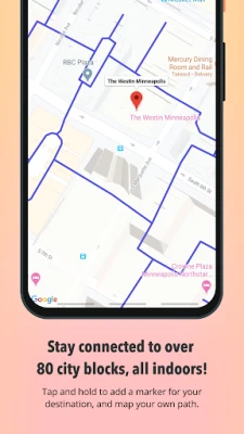
Tap and hold on map to add a marker.
Search and skyway hours coming soon!
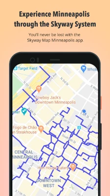
The skyway system offers climate-controlled pedestrian bridges connecting various buildings in downtown Minneapolis. It covers 80 full city blocks over 11 miles. Pedestrians can access the city's entertainment venues, restaurants, hotels, retail stores, banks, apartments, corporate and government offices, and more. Look for access points to and from the street level.
Send feedback to [email protected]!
Rate the App
Add Comment & Review
User Reviews
Based on 0 reviews
No reviews added yet.
Comments will not be approved to be posted if they are SPAM, abusive, off-topic, use profanity, contain a personal attack, or promote hate of any kind.


More »

Popular Apps

SB Connect–Santa BarbaraGranicus LLC

Pinterest Video DownloaderSpaple

Darkness and Flame 3 CEFIVE-BN GAMES
COBOL IDE & CompilerClement Ochieng

Heja Sports Team CommunicationHeja Sports
3D CUBIC 15 GAME by KubokEugenio Coppo
Pixel Cubic 3D - Icon PackGomoTheGom
Microsoft PowerPointMicrosoft Corporation
TrashCash: We Value Your TrashTrashCashPH

Darkness and Flame 3FIVE-BN GAMES
More »
Editor's Choice
Japan VPN – Secure Proxy 4.57FREE VPN PLANET S R L
Infinity Ops: Cyberpunk FPSAzur Interactive Games Limited
TrashCash: We Value Your TrashTrashCashPH
Olathe Trash DayCity of Olathe, Inc.

NeuroNation - Brain TrainingNeuroNation
Pinterest Video DownloaderSpaple
Post-it®3M Company
Tinder Dating App: Chat & DateTinder LLC

Behance - Creative PortfoliosAdobe Inc

BDdata00